About the Project
Who is behind the Project?
Cartography meets History and Vice Versa
The University of Vienna (Department of Geography and Regional Research) is cooperating with the Austrian Academy of Sciences (Institute for Medieval Research, Tabula Imperii Byzantini Balkans) and the Leipzig University of Applied Sciences (Faculty of Computer Science and Media) to conduct the project "Beyond East and West: Geocommunicating the Sacred Landscapes of "Duklja" and "Raška" through Space and Time (11th-14th Cent.)". This international project (I 4330-G) is funded by the Austrian Science Fund (FWF) and the German Research Foundation (DFG).
Duration: 1 March 2020 - 31 August 2023
The Story behind the Project
In the current discourse on the integration of the Western Balkans into the EU the ongoing and envisaged negotiations with the Republics of Montenegro, Serbia and Albania seem to be of remarkable importance in the contemporary media coverage. They comprise a region, which – in a long ago past – played, under the name of Illyricum (Illyrikon), a vital role in the strategic and administrative considerations of the Byzantine Empire.
The project builds upon a scholarly symbiosis of the academic fields of Byzantine Studies, Medieval History, Historical Geography, Art History, Geography and Geocommunication (GIScience and cartography). Its aim is to analyse – from a structural and a historical geographical point of view – the two historic regions of "Duklja" and "Raška" as "Sacred Landscapes".
Research Questions
Crucial is research on both historic regions, which could both prove to be constituting a zone "Beyond East and West", subject to remarkable processes of transformation from the 11th to the 14th centuries, and which have the huge potential to offer data suitable for visualisations as well as formalisation by GIScience.
In addition to the historical questions, the project has a strong focus on historical geography. The spatial aspect in the questions raised in this project is very pronounced. Geocommunication provides a rich repertoire to represent space. Interactions between centres of power, their influence on the region of research and transformations of the "Sacred Landscape" are processes not only in time, but also in space..
With regard to the previously mentioned research questions, Geocommunication assists in the following ways:
 To communicate the results of the spatial analyses as well as the historical and archaeological data and the spatial relations thereof, the project creates an interactive and dynamic map-based online application, which is entitled "Maps of Power - Karten der Macht". It is an integral part of the project and provides a framework for various aspects of the project. Querying the TIB OpenAtlas Database and overlaying various thematic layers, allows the user to explore the data and retrieve spatial relations, yet undiscovered.
To provide an ideal cartographic background for the historical and archaeological data, layers of maps are designed with the specific needs for this project in mind. These maps are based on freely available data, which was be edited and refined by the project team.
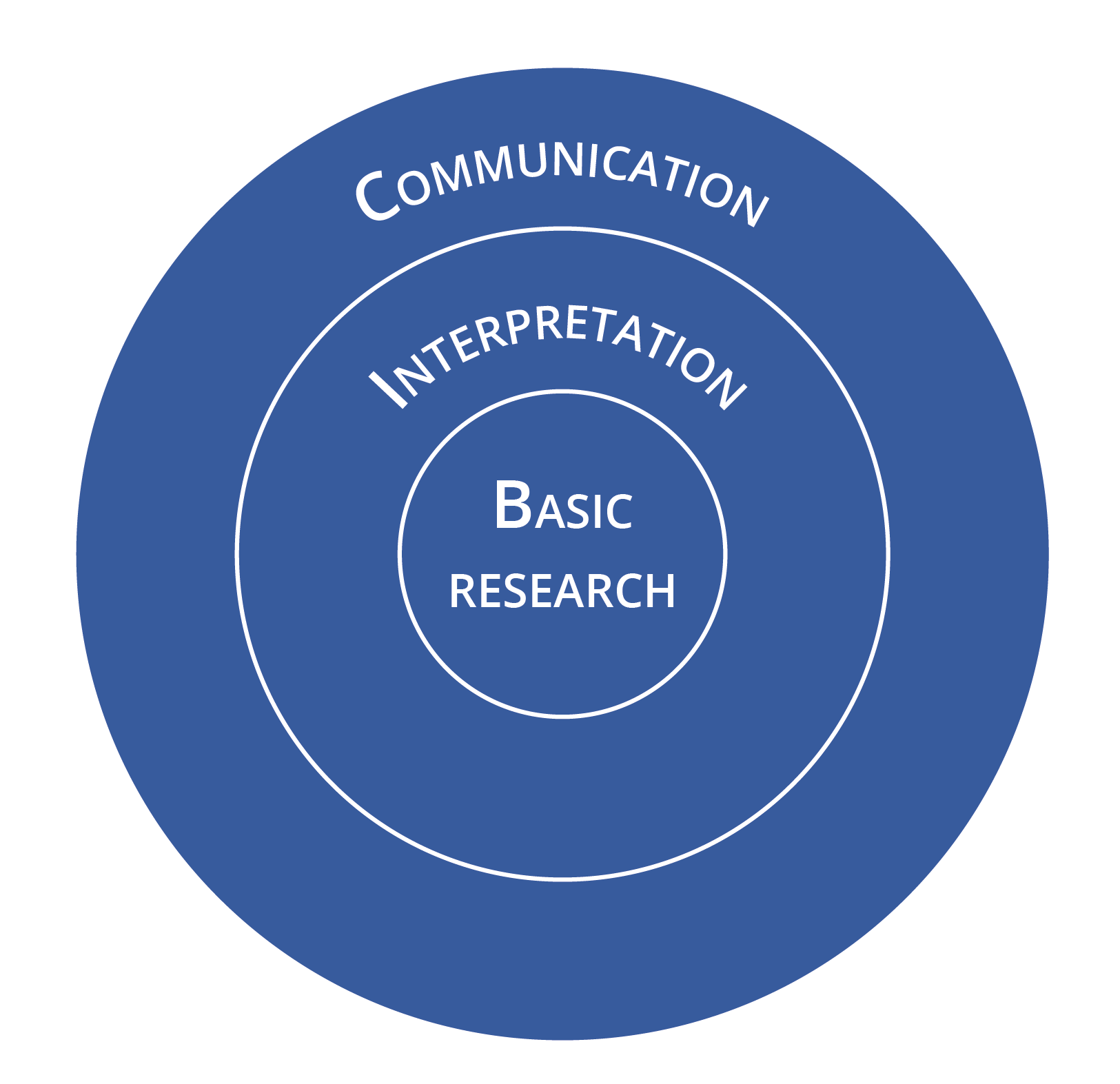
Research
In the field of “Basic Research” HOLDURA is closely connected to the ongoing scholarly work on TIB volume 17 “Nea Epeiros and Praevalis”, which is an integral part of the Long-Term Project Tabula Imperii Byzantini at the Austrian Academy of Sciences in Vienna and which he has begun in 2020. Data from written sources and the bibliography regarding the Historical Geography and Art History of “Duklja” and “Raška” was entered into the Database, which is used to store and query data sets of HOLDURA. This was done to create a solid basis of evidence on settlement patterns and ritual places. The focus lies on churches, monasteries, fortresses, towns, fortified settlements and villages.
In a second step, the Database for the em¬bedded churches and monasteries in the area of research were queried in order to address the aforesaid research questions. Via map visualisation of this data, several patterns of the “Sacred Landscape” of the given area can be observed in the time range between the 11th and 15th centuries. When considering the ter¬ritory of today’s Montenegro including some of its neighbouring areas (on the Northern boundary, South-East to the Lake Shkodra, and West on the coastal area towards Dubrovnik), the location of 43 ritual places can be determined for the beginning of the 11th century. In the given landscape, there is a total increase of 27 churches and monasteries in the time span between the 11th and the first half of the 15th centuries. In this respect, the focus of research lies on the specific clusters and patterns emerg¬ing from the perspective of dedications.
On the one hand, there is a visible increase in Marian devotion in the South-Eastern coastal area, as well as in its Northern hinterland. Dedications of Saint Nicholas augment near the Lake Shkodra and in Budva as well. On the other hand, in some parts, e.g. in the city of Kotor or the Northern hinter¬land, dedications to patron saints from the 11th century onwards are rather heterogenic.
Based on this data, it is possible to raise several further research questions and bring to light diverse aspects. Firstly, an important determining aspect of the “Sacred Landscape” is the distribution of the Latin and the Orthodox rite (dedication respectively) among the ritual places: which places tended more to one or to the other, which were clearly Latin, which not?
In a third step the question of the location of ritual places and their interdependency with the medieval road network was addressed. For this purpose, the georef¬erenced orthophoto of the Austro-Hun¬garian Relief Map of Montenegro was used. Its preindustrial roads were compared with the bibliography on the road network in the area. This gives the possibility to research if certain dedications (cults of Saints) were spreading to the coastal areas from the hinterland or vice versa via these routes of communication. This again will help to understand in which way the “Sacred Landscape” was shaped through the centuries.
Small objects of art, which are kept in churches and monasteries as well as museums and similar collections in the Republics of Serbia and Montenegro (e.g. the National Museum of Serbia, the Museum of the Serbian Orthodox Church, the Museum of Applied Arts, the Gallery of Frescoes, all in Belgrade; the National Museum of Montenegro in Cetinje etc.) are selected for analyses and comparison by the project team. By dating and/or re-dating and comparing these artifacts to other entries in the database, the cultural and religious interchange in the area of research is investigated.
With all this combined, a first picture of the area emerges: There has been a rivalry between Rome and Constantinople in political and ecclesiastical issues on a local level in Duklja as seen in the medieval written sources, and a mutual enrichment in architecture. The analysis of the respective monuments in situ shows that there is no discernable clear cut differentiation between East and West in the “Sacred Landscape” of Duklja in this very period of time. Both East and West are interacting on various levels, which makes Duklja actually an area “beyond East and West”.
From the viewpoint of space, a “missing link” is apparent between the coastal area and its hinterland, which can neither be bridged by the written sources, nor by the toponymy, nor by the existing monuments. The evidence can be interpreted in a way that a stronger religious differentiation between the Latin and Orthodox Churches and a lasting political homogenisation started to take shape with the Nemanjid Dynasty, especially in the 12th and 13th centuries. So, the subsequent question arises, where the gateway has opened to connect the coast and hinterland and where the Nemanjid Dynasty started to empower the homogenisation with regard to the above medieval road network. A working hypothesis, which will be addressed during the reminder of the project, is that the gateway and at the same time “missing link” could have been the Monastery of Morača, which was built by Stefan, the son of Vukan Nemanjić and grandson of Stefan Nemanja, and foreshadows architectural elements from East and West likewise, which could have had a huge impact on the entire area of research.
Geocommunication
Geocommunication provides a rich repertoire to represent space. Interactions between centres of power and worship, their influence on the region of research and transformations of the “Sacred Landscape” are processes not only in time, but also in space.
Specialized know-how in Geocommunication provides additional insight into the spatial structure of the “Sacred Landscape”. Furthermore, methods of Geocommunication and spatial visualisation will provide a platform of dissemination to communicate the scope of the project to academia and the interested public.
The OpenAtlas database of the project is designed specifically for historical and archaeological data and is able to map relationships between actors, places and events. The map-based web application is designed to access the information of the database and provide a map-based query and visualization interface, where the user can explore the often complex relations between different entities and their spatial dimension. In this way, historical landscapes can be explored and communicated. The data on the Balkans acquired during the precursor project “Digitizing Patterns of Power” was integrated into this project’s database, thus forming a large pool of archaeological and historical data, which can be utilized to answer the research questions of the proposed project.
Specific base maps were developed, which are custom tailored to the needs of Historians and Archaeologists by using free geodata. Two versions were designed: one is an approximation to the historical landscape, the other including modern features. These base maps are complemented with further map layers, for example the relevant map sheets of the TIB.
One of the aims of Geocommunication is to communicate spatial transformation processes taking place in the “Sacred Landscape” during the Middle Ages. State-of-the-art methods in Geocommunication and Geovisualization will provide a sound basis, upon which these innovative representations will be created.

Team
Austrian Academy of Sciences, Institute for Medieval Research, Division of Byzantine Research
 Mihailo Popović
 Bernhard Koschiček-Krombholz
 Dorota Vargová
University of Vienna, Department of Geography and Regional Research
 Karel Kriz
 Alexander Pucher
 Markus Breier
 Lukas Neugebauer
 Daniel Nell
Leipzig University of Applied Sciences, Faculty of Computer Science and Media
 Johannes Tripps
 Branka Vranešević
Partners
Institute for Medieval Research,
Division of Byzantine Research
Mihailo Popovic (PI), Byzantine Studies and Historical Geography
Department of Geography and Regional Research,
Karel Kriz, Cartography and Geo-communication
 Leipzig University of Applied Sciences,
Faculty of Computer Science and Media,
Johannes Tripps, Art History
Related Projects
Papers and Publications
Papers:
Markus Breier, Karel Kriz, Alexander Pucher, Lukas Neugebauer, 2021: Beyond East and West – Geocommunicating Historical Sacred Landscapes, in: Proc. Int. Cartogr. Assoc., 4, 14, 2021. (https://doi.org/10.5194/ica-proc-4-14-2021). [Peer Reviewed]
A. Bracanović, M. Breier, M. Hernández Cordero u. a., 2022: On the Crossroads between East and West: Geocommunicating Medieval Sacred Landscapes in Today’s Montenegro – First Project Results. DOI: 10.25536/2022q004. [Peer Reviewed]
Branka Vranešević 2023: Iconography of the Parapet Slab from the Church of St. Thomas in Kuti: New Reflections and Possible Interpretations. Zbornik Matice srpske za likovne umetnosti (Novi Sad) (in print).
Katrin Haase, Johannes Tripps 2023: Jenseits von Ost und West, In: Forschungsmagazin der HTWK Leipzig Einblicke 2023 (Leipzig).
Presentations:
Year 2021
Markus Breier (2021): Montenegro in Miniature – An Analysis of the Historical Relief of Montenegro in Cetinje. Intenational Medieval Congress 2021 (Leeds, UK, online), 5 - 9 July 2021.
Markus Breier (2021): Beyond East and West – Geocommunicating Historical Sacred Landscapes. International Medieval Congress, University of Leeds (Leeds), 7 July 2021.
Markus Breier, Karel Kriz, Lukas Neugebauer, Alexander Pucher (2021): Beyond East and West – Geocommunicating Historical Sacred Landscapes. 30th International Cartographic Conference 2021 (Florenz), 18 December 2021.
Year 2022
Mihailo St. Popović (2022): Пројекат Tabula Imperii Byzantini: о будућности (?) проучавања историјске географије Византије. Serbian Academy of Sciences and Arts - SANU (Beograd), 22 February 2022.
Mihailo St. Popović (2022): On the Use and Usefulness of Digital Humanities in the Historical Geography of Byzantium. Seminar Series: The Balkans Between Empires, Aristotle University of Thessaloniki, Ibn Haldun University Istanbul (Thessaloniki), 1 April 2022.
Mihailo St. Popović (2022): Historical Geography, Digital Humanities and Database Systems: an Approach to reconstruct “Sacred Landscapes” – the Case of Medieval Duklja and Raška (today’s Montenegro and Serbia). Global Eurasia, Workshop II: Handlungsspielräume, Netzwerke und transregionale Kontexte (Wien), 12 May 2022.
Markus Breier (2022): Modern Cartographic Representations of Medieval Borders and Border Zones. International Medieval Congress (Leeds), 6 July 2022.
Moisés Hernández Cordero (2022): Mapping Cultural Heritage beyond the Eye: The Case of the Crown of the Serbian King Stefan Dečanski. International Medieval Congress (Leeds), 6 July 2022.
Lukas Neugebauer (2022): Experiencing Historical Landscapes Using Visual Storytelling. International Medieval Congress (Leeds) 6 July 2022.
Mihailo Popović (2022): Beyond East and West: Sacred Landscapes in the Territory of Today's Montenegro, 11th-14th Centuries. International Medieval Congress (Leeds), 6 July 2022.
Dorota Vargová (2022): An Ecclesiastical History of Medieval Duklja: A Landscape Defined by Rite. International Medieval Congress (Leeds) 6 July 2022.
Branka Vranešević (2022): Towards Imperial Dignity: A Contribution to the Study of the Imperial Crown of King Stefan Uroš III Dečanski in the Cetinje Monastery. International Medieval Congress (Leeds), 6 July 2022.
Markus Breier (2022): Beyond East and West - A Framework for Researching and Communicating Historical Landscapes. EuroCarto 2022 (Vienna), 19 September 2022.
Markus Breier (2022): The Sacred Landscape of Medieval Montenegro: Map-Based Communication. 5. Geographie-Werkstatt des Österreichischem Geographieverbands (Vienna), 20 September 2022.
Mihailo St. Popović (2022): Doing Historical Geography in A Digital Age: The Case of The Tabula Imperii Byzantini Balkans and Its Public Outreach. 2022 Byzantine Studies Conference (Los Angeles), 6 November 2022.
Mihailo St. Popović (2022): Die historische Geographie von Byzanz neu gedacht – Über den Wert der digitalen Kartographie und Geokommunikation in der Vermittlung historischer Inhalte am Beispiel des Projektes „Jenseits von Ost und West“. Deutsche Gesellschaft für Kartographie e.V., Sektion Halle – Leipzig (Leipzig), 10 November 2022.
Year 2023
Bernhard Koschiček-Krombholz 2023: OpenAtlas: Handling Entangled Data in a Linked Data World. International Medieval Congress (Leeds), 6 July 2023.
Mihailo St. Popović 2023: A Mother and Two Sons: the Serbian Rulers Helen, Dragutin, and Milutin and Their Entangled Realms in Medieval Serbia. International Medieval Congress (Leeds), 6 July 2023.
Johannes Tripps 2023: Objects of Private Devotion as Witnesses to Entanglement between Venice and the Árpád and Nemanjić Dynasties. International Medieval Congress (Leeds), 6 July 2023.
Dorota Vargová 2023: Stefan Uroš I and Helen of Anjou: The Royal Couple's Influence on the Confessional Structure of the Principality of Zeta in the Late 13th and Early 14th Century. International Medieval Congress (Leeds), 6 July 2023.
Branka Vranešević 2023: Initials with Teratological Motifs in the Belgrade Prophetologion: Witnesses of Entanglement between East and West. International Medieval Congress (Leeds), 6 July 2023.